
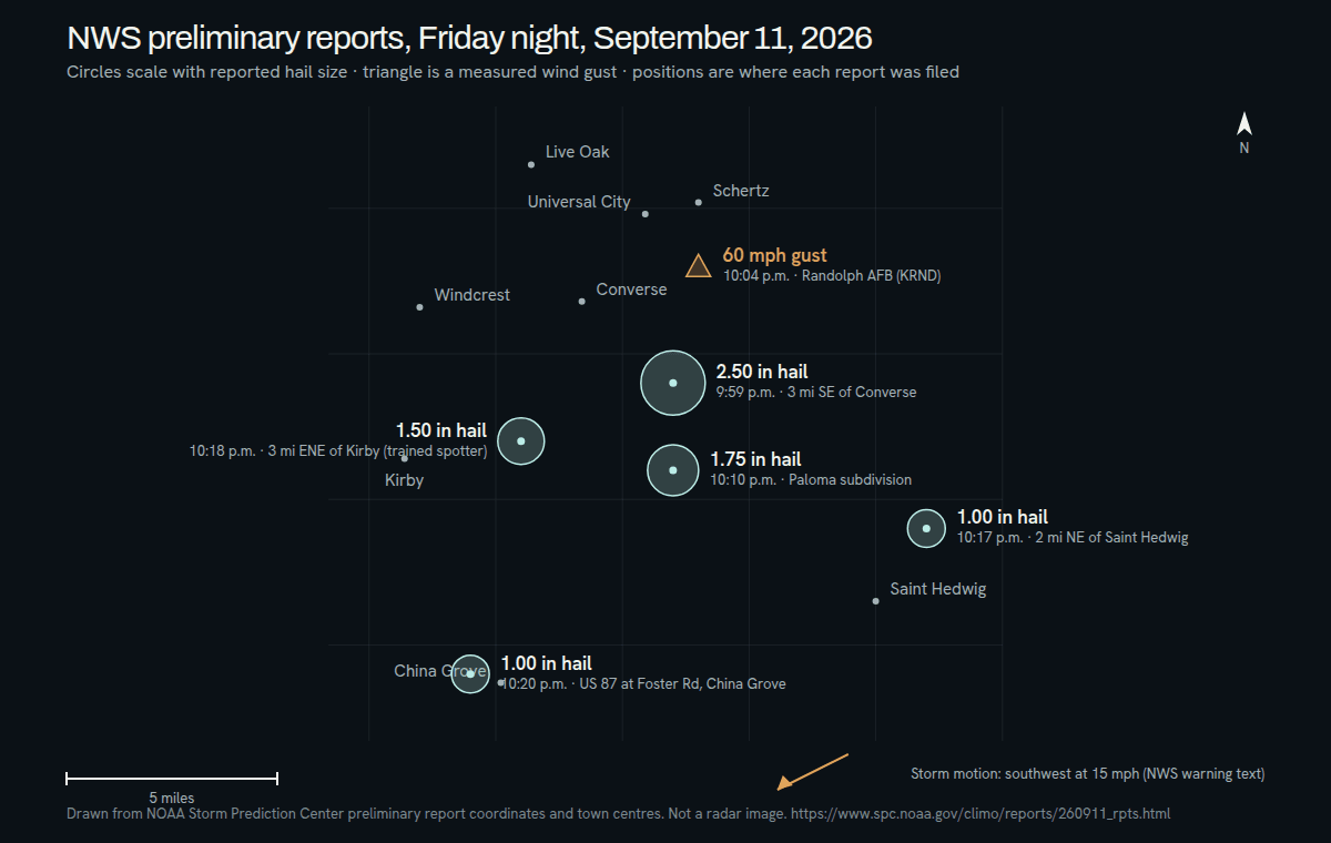
Kirby was not on the edge of Friday night’s storm. It was underneath it. The National Weather Service’s 10:04 p.m. statement and its 10:12 p.m. warning both put the storm ‘over Kirby, or near Converse’, and a trained spotter’s hail report came from three miles east-northeast of town at 10:18 p.m.
To be plain about who we are: Haydent has no shop in Kirby, its single office is at 17601 Ronald Reagan Blvd in Leander, and after the September 11 storm its technicians are inspecting cars where they sit in Kirby, Windcrest and the northeast side of San Antonio, booked at (281) 642-2188 or through the inspection form at /estimate.
Eight minutes from strong to severe
At 10:04 p.m. the weather service was still calling this a strong storm: penny-size hail and 50 to 55 mph gusts, radar indicated. At 10:12 p.m. it became a Severe Thunderstorm Warning for golf-ball hail and 60 mph gusts, with the source line changed to ‘Public’, meaning someone on the ground had reported it. The warning ran until 11:15 p.m. The first product that mentioned damaging hail was issued with the storm already over Kirby.
The storm was moving southwest at 15 mph, which is an unusual direction here. It came in from the Converse side and sat over Kirby through the 10:12 p.m. warning; the reports that followed, near Saint Hedwig and China Grove, are listed on the Converse page.
The Kirby report, and what a trained spotter’s number means
Every Local Storm Report in the NWS archive carries a source type. The distinction that matters in Kirby is between a report relayed from the public, often a social-media photo, and a report from a trained spotter. The Kirby row reads: 1.50-inch hail, 3 miles ENE of Kirby, 10:18 p.m., ‘Trained spotter reports 1 to 1.5 diameter hail.’ The archived row files it under Public, but the remark itself credits a trained spotter, someone who has taken the weather service’s spotter training. The Local Storm Report was issued at 10:25 p.m. It is the larger of the two trained-spotter calls that night; the other is the one-inch report near Saint Hedwig, listed on the Converse page.
The Express-News, in a story posted at 11:21 p.m., put it this way: ‘trained storm spotters had reported hail up to 1.5 inches in diameter between Converse and Kirby – on the East Side – just before 10:30 p.m. Friday night.’ That phrase, between Converse and Kirby, is a good description of where the 10:18 p.m. point sits.
Why 1.5 inches in Kirby and 2.5 inches in Converse are not in conflict
The Converse page holds a 2.50-inch report built from social-media photos, with its location and time estimated from radar by the weather service itself. The Kirby report is a trained spotter’s report from about four miles west of that point, nineteen minutes later. Different place, different minute, different kind of source. Hail falls in a swath narrower than the storm itself, and stone size varies across it, so two observers a few miles apart can report different sizes. Read together, the two reports describe a storm whose biggest hail fell on the Converse side and which was still dropping inch-and-a-half stones as it crossed toward Kirby. Neither report says anything about a particular driveway. Only an inspection does that.
Paintless dent repair for inch-and-a-half hail
As a tendency, smaller stones leave smaller and shallower dents, and shallow dents in sound paint are the case paintless dent repair is suited to: the technician works the metal back from behind the panel and the original factory finish stays on the car. That is a tendency, not a rule. A stone that hits a panel edge, a roof rail or a sharp body line can leave a dent that PDR cannot fully resolve, and cracked paint, stretched metal or broken glass call for panel replacement, paint or glass work, all of which Haydent also performs under the same lifetime workmanship warranty. An inspection comes before any estimate, and the inspection decides.
The lights went out around 10:30 p.m.
KENS 5, citing CPS Energy, framed the night as more than 8,000 people without power, and the station’s 10:39 p.m. update put most of the outages on the east side around Kirby and Converse, about 4,600 of them. Those are the outlet’s figures from the CPS outage map, not a statement from CPS Energy itself.
What that means for a car: a lot of people in Kirby heard the hail, lost the porch light, and did not see the hood until Saturday morning. Give your insurer the date the hail fell — Friday, September 11, 2026 — as the date of loss, and the roughly 10:04 to 10:25 p.m. window. Photograph the car in daylight, whole vehicle first and then each panel, and note in your own words where it was parked and that the power was out when the storm passed.
Kirby, Windcrest and the streets between
Kirby is a small city surrounded by San Antonio, with Converse to the northeast and Windcrest to the north. The 10:18 p.m. report point, three miles east-northeast of the city center, lands on the Converse side of town. Both warning products named Kirby, Windcrest and San Antonio in the same breath, so if the car was parked in Kirby, in Windcrest, or on the northeast San Antonio streets between them and the Converse line, this is your page. We inspect at your driveway or workplace; nobody has to drive a dented car across the city to find out what it needs.
The two Kirby details to add when you call
- The window for Kirby: Friday, September 11, 2026, between about 10:04 and 10:25 p.m. If the car was parked somewhere else at 10 p.m. and driven home later, say so; the storm’s position at 10:04 and 10:12 p.m. is on this page.
- Whether your street lost power, and roughly when it came back, since it explains why the first photos are from Saturday.
Filing a comprehensive claim in Texas: the Converse page covers it once for the whole storm. ↗
The reports, as filed
September 11, 2026 · Central time- 10:18 p.m.1.50 inch hail3 miles ENE of Kirby
Trained spotter reports 1 to 1.5 diameter hail.
Preliminary reports from the NOAA Storm Prediction Center. Sizes are as reported, not as measured by Haydent.
How the night unfolded
Central time · from the sources below- 10:04 p.m.
Special Weather Statement: Doppler radar was tracking a strong thunderstorm over Kirby, or near Converse, moving southwest at 15 mph, with penny-size hail and gusts of 50 to 55 mph. Source line: radar indicated. Issued 10:05 p.m.
NWS Austin/San Antonio, Special Weather Statement (GovOneStop archive) ↗ - 10:12 p.m.
Severe Thunderstorm Warning, in effect until 11:15 p.m.: ‘At 1012 PM CDT, a severe thunderstorm was located over Kirby, or near Converse, moving southwest at 15 mph. HAZARD...Golf ball size hail and 60 mph wind gusts. SOURCE...Public.’ Kirby, Windcrest and San Antonio are in the list of locations impacted.
NWS Austin/San Antonio, Severe Thunderstorm Warning (GovOneStop archive) ↗ - 10:18 p.m.
Hail of 1.50 inches three miles east-northeast of Kirby, Bexar County: ‘Trained spotter reports 1 to 1.5 diameter hail.’ Preliminary, as every report on the SPC page is.
NOAA Storm Prediction Center, September 11, 2026 storm reports ↗ - 10:25 p.m.
The National Weather Service’s Austin/San Antonio office issues its Local Storm Report for the Kirby observation, seven minutes after the hail fell. The archived row files the source as Public and carries the trained-spotter remark.
Iowa Environmental Mesonet, NWS EWX Local Storm Report archive ↗
Where Haydent is taking work
- Kirby
- Windcrest
- Converse
- Northeast San Antonio
Hail cores are narrower than the storms that carry them. If your street is not on this list and your car is dented, it still counts — call and say where you were parked.
Nearby, from the same night
Questions from Kirby this week
The spotter near Kirby said 1 to 1.5 inches. The Converse photos show 2.5. Which one applies to my car?
Neither, strictly. The Kirby number is a trained spotter’s report from three miles east-northeast of town at 10:18 p.m., made by someone who has taken the weather service’s spotter training, and it is filed as a range, 1 to 1.5 inches, not a single stone. It describes one point in a moving storm, not your driveway; the Converse page explains its own 2.50-inch report and how it was placed. Treat the two numbers together as a range for the area. What actually hit your car is settled by looking at the panels, which is what the inspection is for.
Power was out on my street and I did not see the damage until Saturday morning. Does that change the claim date?
No. Give your insurer the date the hail fell, Friday, September 11, 2026, as the date of loss, whether you saw the dents that night or at breakfast. KENS 5, citing CPS Energy, reported about 4,600 outages around Kirby and Converse that evening, so a dark driveway was the normal experience here. Tell your insurer the storm date and the roughly 10:04 to 10:25 p.m. window, note that your street was without power, and take your photographs in daylight.
The SPC row is filed as Public but the remark says trained spotter. Which is it?
Both appear in the record, and the remark is the more specific of the two. The archived Local Storm Report for the 10:18 p.m. observation carries Public in its source column, while the remark reads ‘Trained spotter reports 1 to 1.5 diameter hail.’ We quote both on this page rather than choose between them. For a car in Kirby the remark is the useful part: the number came from someone who has taken the weather service’s spotter training, not from a photo scaled by eye. The National Weather Service issued the report at 10:25 p.m., and like every entry on the Storm Prediction Center page it is preliminary.
Is Kirby covered by the same crew as Converse, and is it the same number?
Yes to both. Haydent works storm to storm as one operation, and the technicians taking Converse work after this storm are the same ones taking Kirby, Windcrest and northeast San Antonio. There is one number, (281) 642-2188, and one inspection form at /estimate. We come to the car, so distance from Converse is not a factor; tell us where it is parked and we will schedule the visit from there. Our office is in Leander, and we will always say so.
My car was at work in Converse at 10 p.m. and home in Kirby by midnight. Which location do I give?
Give both, with times. The warning placed the storm over Kirby at 10:12 p.m. after it had crossed the Converse side, and Kirby’s own window runs from the 10:04 p.m. statement to the 10:25 p.m. report, so a car that moved during the storm may have been under it twice or once or not at all. Write down where it was parked at each point and when it moved. An insurer wants an honest account, not a guess at the nearest report on a map, and the inspection will show what the panels took regardless.