
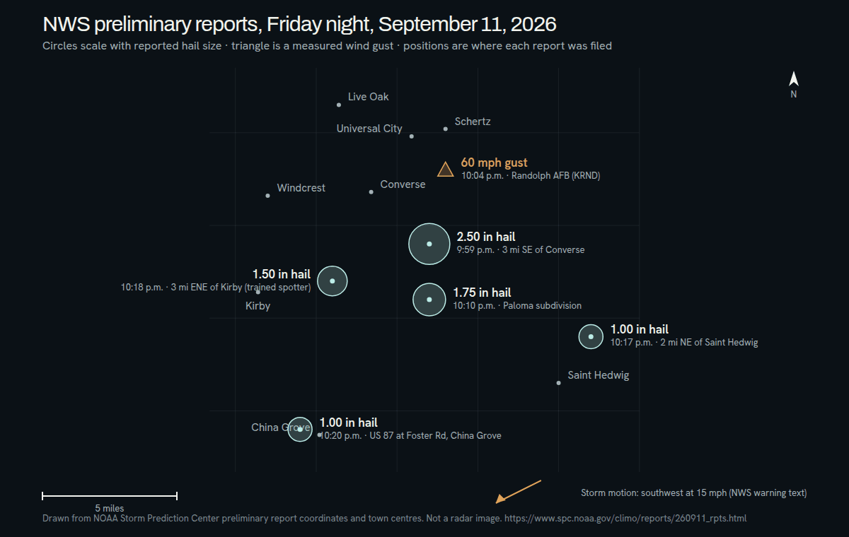
A line of storms crossed the east side of the San Antonio metro late on Friday, September 11, 2026. Within about twenty minutes the National Weather Service had preliminary hail reports from Converse, Kirby, China Grove and Saint Hedwig, and a measured 60 mph gust at Randolph AFB. This is a dated report on that night, not a current weather warning.
What the preliminary reports show
- Converse: 2.50-inch hail three miles southeast of town at 9:59 p.m., logged from numerous social media pictures showing hail in the 2 to 2.5 inch range — and, in the same remark, broken windshields and car windows.
- Converse, Paloma subdivision: 1.75-inch hail four miles south-southeast at 10:10 p.m., reported as dime to golfball sized between 10:05 and 10:15 p.m.
- Kirby: 1.50-inch hail three miles east-northeast at 10:18 p.m., from a trained spotter reporting 1 to 1.5 inch stones.
- Saint Hedwig: 1.00-inch hail two miles northeast at 10:17 p.m.
- China Grove: 1.00-inch hail one mile west-southwest at 10:20 p.m., relayed by broadcast media near Highway 87 and Foster Road.
- Schertz: a 60 mph wind gust two miles south at 10:04 p.m., measured by the AWOS station at Randolph AFB.
These are preliminary observations, not a complete map of the damage. Individual entries can later be corrected or duplicated, and the absence of a report from your street means only that nobody filed one.
“Golf ball” and 2.50 inches are not the same report
Friday night’s coverage said golf-ball hail, and the Paloma subdivision report is exactly that: on NOAA’s size table a golf ball is 1.75 inches. The 2.50-inch report three miles southeast of Converse is a tennis ball on the same table, and the National Weather Service notes that its time and location were estimated from radar rather than measured at a fixed point. Both are real; they describe different places a few miles apart.
Two and a half inches is a different conversation
Hail at an inch will dent a hood. Hail at two and a half inches arrives with enough energy to crack glass, which is exactly what the Converse remark describes. When glass is involved, photograph it with the same care as the panels: windshield, back glass, sunroof, mirrors and lamp lenses all belong in the record.
Large hail also makes the inspection more important rather than less. Paintless dent repair depends on the paint surviving the impact and on the metal not being stretched past what it can be worked back to. Those are findings, not assumptions, and they come from looking at the car.
Turn Friday night into a record
Note where the vehicle was parked at around 10 p.m. on September 11 and keep that note with the photos. If it moved during the storm, write down each location rather than choosing the nearest report on a map. Photograph the whole vehicle first, then the hood, roof and trunk, then close views of individual dents. Keep the original image files; a screenshot of a photo loses the detail that matters later.
If you are filing a claim, confirm coverage, deductible and any rental benefit with your insurer directly — those terms are specific to your policy — and have the claim number and any existing estimate ready for the inspection.
The map is the storm. The estimate is your car.
Two cars parked on the same Converse street can come out of the same twenty minutes very differently. Which way the vehicle faced, whether a carport or a tree took part of the impact, panel shape and paint condition all change the outcome. A hail report explains the night. The repair plan comes from examining the vehicle itself.