
Between 10:04 and roughly 10:55 p.m. on Friday, September 11, 2026, one thunderstorm crossed the east and south sides of Bexar County. This page is the metro record: the National Weather Service products in the order they were issued, the outage numbers two outlets reported, the reasons the storm gets confused with a bigger one, and which of Haydent’s town pages applies to where your car was parked.
Haydent has no San Antonio shop; the work is mobile from a Leander office, so call (281) 642-2188 or request an inspection at /estimate and say where the car was parked that night.
How the storm moved across Bexar County
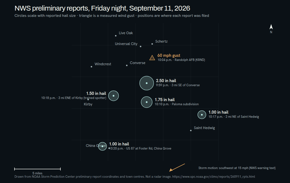
Every product that night gave the same motion: southwest at 15 mph. The cell started over Kirby and Converse, was near China Grove by 10:25 p.m., and was near Stinson Municipal Airport by 10:34 p.m. That track runs from the northeast suburbs, across the east side, to the south side, and it explains why the largest hail is recorded at the beginning of the timeline and the smallest at the end.
Kirby: eight minutes from strong to severe ↗
The Storm Prediction Center’s list for the reporting day is preliminary and stays that way until the NWS publishes its Storm Data. Six reports in the San Antonio area were filed for this storm, and every one of them falls inside Bexar County. Each is carried in full on its town’s page, and the largest by town is listed under Which page is yours below. Inside San Antonio city limits there is no preliminary report of any kind, though the Express-News placed the warning over downtown.
Inside the city limits: what the record holds
The 10:12 p.m. warning polygon took in the independent cities inside the San Antonio area that the product named — Alamo Heights, Terrell Hills and Olmos Park — along with Windcrest, which the Kirby page covers, and Stinson Municipal Airport, Lackland AFB, Elmendorf, Calaveras Lake and Sandy Oaks to the south. A place named in a warning is a place the polygon covered. It is not a place where hail was observed, and none of those places has a preliminary report of its own. The Express-News wrote that the warning covered downtown San Antonio as well.
What exists for the city proper is viewer material. KSAT published photos and video sent to KSAT Connect from about 10 p.m. onward, pinned to the Northeast Side and the I-10 East corridor, and wrote that some areas received hail and more than two inches of rain without saying which areas. KSAT gave no hail sizes of its own. If your car sat in one of the warned places, the honest reading is: the storm was overhead, the record is silent, and the panels are the evidence.
Schertz: what a warning with no report behind it means for your car ↗
Power outages, as the two outlets counted them
No CPS Energy statement specific to this storm was published. What exists are two newsrooms reading the utility’s outage map. KENS 5, citing CPS, reported more than 8,000 customers without power at 10:30 p.m., most of them on the east side, and fewer than 2,000 by 11 p.m.; an earlier version of the same story carried a lower headline figure. The Express-News put the count above 1,900 at 10:55 p.m. Both agree on the shape: a sharp spike during the storm and most of it restored inside an hour. The east-side breakdown sits on the Kirby page.
This was not the August 28 wind storm
Search results for San Antonio storm damage in September 2026 mix two events together. On Friday, August 28, 2026, straight-line winds crossed the city along a 35-mile damage path, and more than 250,000 CPS Energy customers lost power at the outset — a different storm, two weeks earlier, surveyed by the National Weather Service and written up by CPS Energy in its restoration update. The September 11 storm was one hail-producing cell that was severe for well under an hour, with outages that KENS 5, citing CPS Energy, put above 8,000 at 10:30 p.m. If a figure you have read sounds like a citywide disaster, it belongs to August 28, not to the hail.
The week after: nothing followed it
The Storm Prediction Center’s reports for Saturday, September 12 list Texas entries only in the Panhandle, and its list for Sunday, September 13 has no Texas entries at all. The NWS Austin/San Antonio forecast discussion issued at 6:15 p.m. on Sunday, September 13 calls the pattern mainly dry under a ridge through Wednesday, with rain chances of 10 to 20 percent along I-35 and otherwise confined to the coastal plains until a possible surge in moisture on Thursday. It mentions no hail and no severe weather for San Antonio. Forecasts change; the discussion is reissued several times a day and the link is in the sources.
Which page is yours
Pick the page by where the car was parked around 10 p.m. Friday, not by your mailing address. Each town page carries its own reports in full, its own warning quotes and its own questions.
Converse: the two largest reports, 2.50 and 1.75 inches, and the Paloma subdivision ↗
Kirby and Windcrest: the 1.50-inch trained-spotter report and the storm’s position at 10:12 p.m. ↗
Saint Hedwig and China Grove: one-inch hail on the US 87 corridor and the storm’s turn southwest ↗
For the rest of the metro — the Northeast Side, the I-10 East corridor, the south side around Stinson, and the independent cities of Alamo Heights, Terrell Hills and Olmos Park — there is no town page, because there is no report to build one on. This page is your page. Windcrest sits on the Kirby page; Cibolo, Live Oak and Selma sit on the Schertz page.
What the inspection needs from you
For this page, one thing the town pages do not ask for: the location of the car around 10 p.m. on September 11, as an address or a cross street, and a second location if it moved, because on a metro page that is what tells the technician which side of the track the car was on. The rest of the checklist is the same everywhere.
Converse: what to do this week — photographs, claim number, and what to confirm with your insurer ↗
The reports, as filed
September 11, 2026 · Central timePreliminary reports from the NOAA Storm Prediction Center. Sizes are as reported, not as measured by Haydent.
The night, product by product
Central time · from the sources below- 10:04 p.m.
Special Weather Statement, issued 10:05 p.m.: a strong thunderstorm over Kirby, or near Converse, moving southwest at 15 mph, with penny size hail and gusts of 50 to 55 mph, radar indicated. Quoted in full on the Kirby page.
NWS Austin/San Antonio Special Weather Statement (GovOneStop archive) ↗ - 10:12 p.m.
Severe Thunderstorm Warning, in effect until 11:15 p.m.: the storm over Kirby, or near Converse, with golf ball size hail and 60 mph gusts. The Kirby page carries the warning text; the Schertz page carries its list of locations.
NWS Austin/San Antonio Severe Thunderstorm Warning (GovOneStop archive) ↗ - 10:26 p.m.
First warning update: the storm near China Grove, seven miles northeast of Stinson Municipal Airport, with quarter size hail and 60 mph gusts, radar indicated. Quoted in full on the Saint Hedwig and China Grove page.
NWS Austin/San Antonio Severe Thunderstorm Warning update (GovOneStop archive) ↗ - 10:34 p.m.
Second warning update: the storm near China Grove, or near Stinson Municipal Airport, with nickel size hail and 60 mph gusts, radar indicated, and weakening. Quoted in full on the Saint Hedwig and China Grove page.
NWS Austin/San Antonio Severe Thunderstorm Warning update (GovOneStop archive) ↗ - 10:55 p.m.
Per the Express-News, the warning was cancelled early at 10:55 p.m. as the storm weakened, with more than 1,900 CPS Energy customers still without power on the utility’s outage map at that moment. The cancellation product itself is not archived where the earlier products are, so this entry rests on the newspaper alone.
San Antonio Express-News (Yahoo syndication) ↗
Town by town
Where Haydent is taking work
- Northeast Side
- The I-10 East corridor
- Alamo Heights
- Terrell Hills
- Olmos Park
- Stinson Municipal Airport
- Brooks City Base
- Lackland AFB
- Elmendorf
- Calaveras Lake
- Sandy Oaks
- Converse
- Kirby
- Saint Hedwig
- China Grove
- Schertz
- Randolph AFB
Hail cores are narrower than the storms that carry them. If your street is not on this list and your car is dented, it still counts — call and say where you were parked.
Nearby, from the same night
Questions from San Antonio this week
Was the September 11 hail storm the same event as the August 28 storm?
No. They were two storms, two weeks apart. August 28, 2026 was a straight-line wind event that crossed San Antonio on a 35-mile damage path, with more than 250,000 CPS Energy customers out at the start; the NWS surveyed it and CPS Energy wrote it up. September 11 was a single hail-producing thunderstorm on the east and south sides that was severe from 10:12 p.m. until it weakened, with outages that KENS 5 put above 8,000 at 10:30 p.m. A claim for hail on September 11 is a different claim from wind on August 28.
Did downtown San Antonio get hail?
The record does not say. The Express-News reported that the 10:12 p.m. warning covered downtown, so the polygon reached it, but the preliminary Storm Prediction Center list has no report inside the city limits; the nearest is 1.50-inch hail three miles east-northeast of Kirby at 10:18 p.m., which the Kirby page carries. The storm’s track ran southwest from Kirby toward Stinson, which keeps it east and south of downtown. If your car was parked downtown, look at the roof and hood in good light before assuming either way.
How do I know which Haydent page is mine?
By where the car was, not where you live. Converse has its own page. Kirby’s page also covers Windcrest. Saint Hedwig and China Grove share a page. The Schertz page covers Cibolo, Universal City, Live Oak, Selma and Randolph AFB. If the car was anywhere else in the metro — the Northeast Side, the I-10 East corridor, the south side near Stinson, or Alamo Heights, Terrell Hills and Olmos Park — this page is yours. Either way the number is the same, (281) 642-2188, and the inspection is the same.
Alamo Heights, Terrell Hills or Olmos Park was in the warning, but there is no report. Did hail fall there?
The record cannot say. The 10:12 p.m. warning named all three, along with Stinson Municipal Airport, Lackland AFB, Elmendorf, Calaveras Lake and Sandy Oaks, and none of them has a preliminary report; the six reports that exist all sit east of the city, and the nearest to these three is the Kirby report. The Schertz page explains why a warning polygon is not an observation and why an absent report is not proof either way. Photograph the car and have it inspected.
Is more hail expected in San Antonio this week?
Not in the forecast as of Sunday, September 13. The NWS Austin/San Antonio forecast discussion issued that evening at 6:15 p.m. describes a mainly dry pattern under a ridge through Wednesday, with rain chances of 10 to 20 percent near I-35 and no severe weather mentioned. The Storm Prediction Center logged nothing in Bexar County on Saturday or Sunday. That is a forecast, not a promise; the discussion is updated several times a day, and the link in the sources is the current one.
How do I read the SPC storm report for September 11?
The Storm Prediction Center lists each report in UTC, so subtract five hours for Central time: 0259 is 9:59 p.m. Hail size is in hundredths of an inch, so 250 means 2.50 inches and 100 means one inch. Location is a distance and direction from the nearest town, as in 3 SE Converse, which is three miles southeast of it. The remark column is the reporter’s words. The list is preliminary until the NWS publishes Storm Data, and it is subject to change until then.
Does Haydent have a shop in San Antonio?
No — Haydent’s corporate office is at 17601 Ronald Reagan Blvd in Leander and the work is mobile, so a technician comes to the vehicle wherever it is parked in the San Antonio area; call (281) 642-2188 or use /estimate and say where the car was on the night of September 11.