
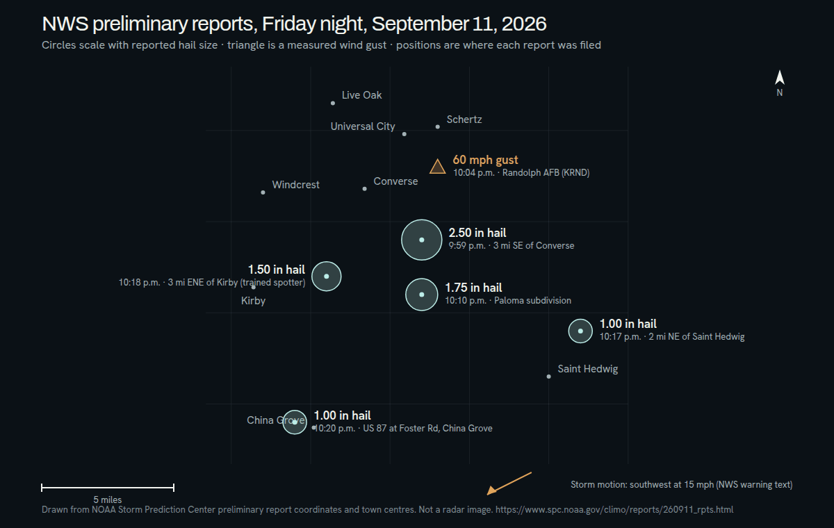
At 10:04 p.m. on Friday, September 11, 2026, the automated weather observing station (AWOS) at Randolph AFB, call sign KRND, measured a wind gust of 60 mph. The National Weather Service filed it as a Local Storm Report two miles south of Schertz, in Bexar County, and issued it at 5:14 p.m. the next day. It is the only instrument-measured observation from the whole storm, and the only report of any kind that names Schertz.
Haydent’s office is in Leander, at 17601 Ronald Reagan Blvd, and there is no Schertz shop; the technician drives to the car, whether it is parked in Schertz, Cibolo, Universal City, Live Oak or Selma, and the inspection happens where it sits. Call (281) 642-2188 or use the inspection request form.
Measured versus seen: what the Randolph AFB gust record is
An AWOS is an instrument. It records wind speed at a fixed height on a fixed site whether or not anyone is watching, and the 60 mph figure is what the anemometer read, not what a person estimated. Every hail report the Weather Service filed that night came the other way: photographs posted to social media, a trained spotter’s call, a figure relayed by broadcast media. Those belong to the Converse, Kirby and Saint Hedwig pages. The Storm Prediction Center’s list is preliminary, and the gust entry can be revised when the Weather Service compiles its final storm data.
A measured gust also has a narrow meaning. It tells you what the wind did on the airfield at that minute. It does not tell you what fell in a driveway in Schertz two miles north, or in Cibolo a few miles beyond that.
No hail report exists for Schertz, Cibolo, Universal City, Live Oak or Selma
The Iowa Environmental Mesonet keeps a copy of every Local Storm Report the Austin/San Antonio office issued from September 11 through the morning of September 14. There are six. Five are hail reports in eastern Bexar County near Converse, Kirby, Saint Hedwig and China Grove. The sixth is the Randolph AFB gust. None places hail in Schertz, Cibolo, Universal City, Live Oak or Selma.
Two readings of that are both wrong. The first is that nothing fell in these towns. Storm reports are voluntary: someone has to see the hail, measure or photograph it, and get it to the Weather Service, and at 10 p.m. on a Friday, in the dark, that often does not happen. The second is that the towns were hit because the warning named them. A warning polygon is drawn around where a storm might go, not where hail landed. Sitting inside it under a golf ball size hail hazard is a reason to check the car, not proof of damage.
Selma is the odd one out. It is not on the warning’s list of impacted locations at all, and it has no report. If your car was parked in Selma that night, the record says nothing either way.
What the 10:12 p.m. warning said about Schertz and Cibolo
The severe thunderstorm warning issued at 10:12 p.m. and running to 11:15 p.m. listed Schertz, Cibolo, Universal City, Live Oak and Randolph AFB among the places in its path, with golf ball size hail and 60 mph gusts as the stated hazard. It placed the storm over Kirby, or near Converse, moving southwest at 15 mph, which is away from Schertz and Cibolo and toward the south side of San Antonio. The San Antonio page follows the storm from there.
Eight minutes from strong to severe — how the warning was built, on the Kirby page ↗
Hail, wind and debris: reading the damage apart
No source reports debris or tree damage in Schertz, and this page will not invent it. What follows is general paintless dent repair knowledge, offered because a 60 mph gust is the one thing the record does show near the town.
- Hail leaves round, shallow dents scattered without pattern, densest on the roof, hood and trunk lid, usually with the paint intact.
- When hail is driven sideways by strong wind it also reaches doors, fenders and quarter panels on the side the wind came from, and those dents can be oval rather than round.
- Wind-thrown debris leaves scratches, paint transfer and gouges along with any dent, often clustered on one face of the car.
- A falling limb leaves a crease or one long dent rather than a field of small ones, and often marks the paint.
- A gust by itself, with nothing carried in it, is not what dents a panel; what the wind throws is.
These distinctions decide the repair. Paintless dent repair works on dents with sound paint and no stretched metal. Scratched or cracked paint from debris is handled differently, and the inspection sorts each panel before an estimate is written.
Randolph AFB and the towns around it
JBSA-Randolph is in Bexar County, with parts of the base property reaching into Schertz and Universal City. Schertz lies to its north and east and is itself split across Bexar, Guadalupe and Comal counties, with Interstate 35 running through it. Universal City sits on the base’s other side, with Pat Booker Road as its main commercial street, Live Oak to its west, Selma to its north and Converse to its southwest. Cibolo, in Guadalupe and Bexar counties, borders Schertz on the east. The gust was logged on the airfield; the nearest hail report, the 2.50-inch Converse entry, is described on the Converse page.
For military families and everyone else around Randolph, Haydent’s answer is the same: the technician comes to the vehicle wherever it is parked, at home or at work, and the inspection happens there.
What to tell us about where the car stood
- The town and the street where the car sat at 10 p.m. Friday, so we know which part of the record applies to it.
- Whether it stood under a carport, beside a tree or in the open.
What to do this week — photos, the claim number and where the car sat, on the Converse page ↗
The reports, as filed
September 11, 2026 · Central time- 10:04 p.m.60 mph wind gust2 miles S of Schertz
“AWOS station KRND Randolph AFB.” Source: AWOS, an instrument reading. Report issued 5:14 p.m. Saturday, September 12.
Preliminary reports from the NOAA Storm Prediction Center. Sizes are as reported, not as measured by Haydent.
What named Schertz that night
Central time · from the sources below- 10:04 p.m.
Special Weather Statement (issued 10:05 p.m.): radar tracking a strong thunderstorm moving southwest, with Schertz, Universal City, Live Oak and Randolph AFB listed among the places in its path. The Kirby page carries the statement’s position and hazard lines.
NWS Austin/San Antonio, via the GovOneStop archive ↗ - 10:04 p.m.
The AWOS at Randolph AFB (KRND) measures a 60 mph gust. The National Weather Service files it as a Local Storm Report two miles south of Schertz, issued at 5:14 p.m. Saturday, September 12.
NWS Austin/San Antonio Local Storm Report, via the IEM archive ↗ - 10:12 p.m.
Severe Thunderstorm Warning until 11:15 p.m.: Schertz, Cibolo, Universal City, Live Oak and Randolph AFB listed as locations impacted under a golf ball size hail hazard.
NWS Austin/San Antonio, via the GovOneStop archive ↗
Where Haydent is taking work
- Schertz
- Cibolo
- Universal City
- Live Oak
- Selma
- Randolph AFB
- Pat Booker Road
- The I-35 corridor
Hail cores are narrower than the storms that carry them. If your street is not on this list and your car is dented, it still counts — call and say where you were parked.
Nearby, from the same night
Questions from Schertz this week
There is no hail report for Schertz. Does that mean no hail fell here?
No. It means nobody sent the National Weather Service a hail measurement or photo from Schertz that became a Local Storm Report. Reports are voluntary and the Storm Prediction Center’s list is preliminary, so gaps are normal, especially late on a Friday night. It also does not mean hail did fall: the 10:12 p.m. warning named Schertz under a golf ball size hail hazard, but a warning describes where a storm might go, not where hail landed. If your car was outside, look it over in daylight and call if you find anything. We inspect before we say what it is.
The 60 mph gust was measured at Randolph AFB. Did that wind reach Cibolo?
The record cannot say. The AWOS at Randolph measured 60 mph at 10:04 p.m. at one point on the airfield, about two miles south of Schertz, and Cibolo lies on the far side of Schertz to the east. The warning issued eight minutes later listed Cibolo among the places in the storm’s path with a 60 mph wind hazard, but that is a forecast for the polygon, and the storm was moving southwest, away from Cibolo. No Local Storm Report was filed from Cibolo for wind or hail. If you are in Cibolo and the car looks wrong, describe where it was parked and we will come look.
How do I tell hail dents from wind or debris damage on my car?
Hail leaves round, shallow dents with the paint usually intact, scattered without a pattern and heaviest on the roof, hood and trunk lid. Debris thrown by wind tends to scratch or gouge the paint along with any dent and clusters on one side of the car. A limb leaves a long crease rather than a field of small dents. The difference decides the repair: paintless dent repair needs sound paint, while broken paint is handled another way. Photograph everything you find and let the inspection sort the panels.
I live in Universal City, Live Oak or Selma. Does this page apply to my town?
Yes. This page speaks for the towns around Randolph AFB that have no storm report of their own: Universal City and Live Oak, which the 10:12 p.m. warning named, and Selma, which it did not. Haydent takes inspection requests from all three, and from Schertz and Cibolo, with the technician coming to the vehicle. Call (281) 642-2188 with the street where the car was parked.
Can a 60 mph wind gust dent a car on its own?
Not by itself. A gust of that speed pushes on a car and can move loose objects, but it is what the wind carries that marks a panel: limbs, gravel, patio furniture, shingles, and hail driven sideways. Hail in strong wind reaches doors and fenders that usually escape it, and the dents can be oval instead of round. No source reports any of that in Schertz, so treat this as what to look for, not what happened. If the car has marks you cannot explain, an inspection will tell you what made them.
The gust report was not issued until 5:14 p.m. Saturday. Why the delay, and does it change my claim date?
No. A Local Storm Report carries two times. The observation time, 10:04 p.m. Friday, September 11, is when the AWOS at Randolph AFB recorded the gust, and that is the date and hour that describe the storm. The issue time, 5:14 p.m. Saturday, September 12, is when the National Weather Service wrote the report up and released it. The report does not say why it came out the next afternoon, and this page will not guess. Give your insurer Friday, September 11 as the date of the storm; how a date of loss is set and reported is a term of your policy, so confirm it with them.